Nanny's Bag VMS
Highlights:
-13 Km east of historic Point Leamington Deposit (PLD)
-Alteration/mineralization indicate prospectivity for VMS
-Up to 346 ppb Au, > .22% Zn, 0.63% Cu and 4.1 g/t Ag
-PLD has NI 43-101 of 14,100,000 tonnes grading 1.86 % Zn, 0.42%
The Nanny Bag Lake Property comprises 2 separate licenses located approximately 10 km south of the town of Point Leamington. The property is accessible from woods roads off Highway 350, just east of the property, which connects the TCH at Bishop’s Falls to Point Leamington (Maps 1 and 2). (NTS 2E/06) (Map 1).
Regional Geology
The Nanny Bag Lake Property lies within the structurally complex, northeastern Exploits subzone (Dunnage Zone) of central Newfoundland. The property covers a large felsic volcanic-intrusive complex centred on Nanny Bag Lake that is part of the Cambro-Ordovician ophiolitic Wild Bight Group. Felsic volcanic rocks elsewhere in the Wild Bight Group host significant massive sulphide deposits and occurrences including the Point Leamington Deposit, Lockport Mine and Seal Bay Prospect. The Badger Group present mostly in the eastern part of the property, comprises a mid-Ordovician to early Silurian shale-turbidite sequence.
Local Geology
The northern licenses are underlain mainly by the Glovers Harbour and Sparrow Cove formations of the Wild Bight Group. The southern license is mainly underlain by the Penny’s Brook Formation of the Wild Bight Group. The latter consists of a bimodal tholeiitic volcanic suite of mafic pillowed and pyroclastic rocks and intermediate to felsic, quartz and feldspar phyric fragmental and flow rocks. The Penny’s Brook Formation comprises mainly siliciclastics, interbedded with volcaniclastic units and, locally, pillow basalts. The Glovers Harbour Formation is bounded to the north east (overlain by?) an extensive sequence of siliciclastics and black shale, perhaps representing a post volcanic basin infill. The Penny’s Brook Formation is commonly recognized as overlying the Glovers Harbour Formation and is considered the upper part of an underlying thrust slice. The repetition of stratigraphy and fault bounding of units is characteristic of thrust stack terrains. These mafic to felsic volcanics have associated gabbroic and granitoid intrusions. The Badger Group consists of Ordovician to Silurian shale-turbidite sequence
Previous Work and Mineralization
There are two historic mineral occurrences on the property, viz the Big Asco Pond Pyrite and the New Bay River Cu-Zn-Au showings (Map 2). The Big Asco ocurrence is underlain by felsic pyroclastics of the Penny's Brook Formation. Mineralization consists of disseminated pyrite hosted by felsic volcanic rocks over an extensive area. At the New Bay River Cu Showing, samples collected during Rubicon’s late 1990’s exploration program, were weakly mineralized with pyrite and five of the samples contained trace amounts of chalcopyrite and sphalerite. One sample, which contained anomalous gold (346 ppb Au) consisted of jasper, hematite and silica (Singh, 2000). Other assays returned > .22% Zn, up to 0.63% Cu and 4.1 g/t Ag. Rubicon carried out a drilling campaign to follow up on EM targets. DDH LL2000-06 intersected grey chert with magnitite but this was not assayed. DDH LL2000-07 intersected 1.6 m of 1415 ppb Au including 3041ppb Au over 0.6 m, contained in grey chert with magnitite. Anomolous Au was intersected from 48.1 to 63.9 m ranging from 12 ppb to 3014 ppb Au. Neither hole satisfactorily explained the EM conductor being followed up. DDHs LL2000-13,14: these holes tested a limited area of a large IP anomaly with at least a 2 km extent, coincident with the west edge of a large magnetic high. Both holes encountered altered and mineralized quartz porphyry and quartz-feldspar porphyry. Alteration and mineralization continued to the end of the holes - 424 m and 153 m respct. These holes intersected extensive zones of 3-10% sulphides including py+/-po+/-cpy+/-sp in fractures, stringers, patchy concentrations and disseminations and included values up to 9898 ppm Cu, over 0.7 m and 2456 ppm Zn, over 0.7 m. The Nanny grid was emplaced after zinc rich mineralization (1-3% Zn, and up to 1.2 g/t Au and 38g/t Ag in grab samples) was discovered. Both holes were collared at the same location. Other EM conductors were not followed up by Rubicon.
Exploration Model
The property lies approx 13 km to the east of the Mining Lease covering the Point Leamington Deposit, which represents the largest accumulation of massive sulphides in the Canadian Appalachians, outside the Bathurst Camp.There are many similarities in the geological setting of the Nanny Bag Lake property with the geology of the Point Leamington massive sulphide deposit, including, i) a prevalence of massive and clastic (brecciated) quartz porphyritic rhyolite and felsic intrusives; ii) presence of extensive hematitic volcanic and volcaniclastic rocks within the quartz porphyritic rocks and may be the peripheral part of an alteration system; iii) locally mixed felsic volcanic/volcaniclastic sequences host chert-jasper and sulphide-rich beds; iv) extensive areas of quartz-sericite-pyrite alteration typical of footwall alteration zones (2 zones of Zn-bearing mineralization were discovered by Rubicon Minerals (McVeigh, 2001)associated with this alteration. The Point Leamington Deposit: The Point Leamington mineralization is a large, felsic-hosted, gold-rich, Zn-Au-Cu-Ag massive sulphide deposit in a nearsurface zone along a 500 m strike length and to depths of 360 m. The most important rock type in the area from an exploration viewpoint is a quartz porphyritic rhyolite occurring as flows and pyroclastics. Much exploration has been carried out culminating in an NI 43-101 Inferred Resource Estimate by Calibre Mining Corp in 2013 at a cut-off grade of 4.0% ZnEq, of 14,100,000 tonnes grading 1.86 % Zn, 0.42% Cu, 0.02% Pb, 1.07 g/t Au and 17.12 g/t Ag (6.15% ZnEq) containing 577M lb zinc, 130M lb, copper, 6.2M lb lead, 484,000 oz Au and 7,755,000 oz Ag. The property was bought out by Newmarket Gold in 2014 who intersected up to 40 m of massive sulphide mineralization and returned a number of intercepts including 13.38 m grading 2.5 g/t Au, 2.44% Zn and 0.90% Cu (PL14-079) and 10.57 m grading 1.0 g/t Au, 4.60% Zn and 0.39% Cu (PL14-078).
Geology Source:
Crisby-Whittle, L. V. J. (compiler): 2012: Bedrock geology dataset for the Island of Newfoundland. Newfoundland and Labrador Department of Natural Resources, Geological Survey, Open File NFLD/2616 version 7.0. Mineral Occurrence Source: Mineral Occurrence Database - Geological Survey, Department of Natural Resources Website: http://www.gov.nl.ca/mines&en/geosurvey


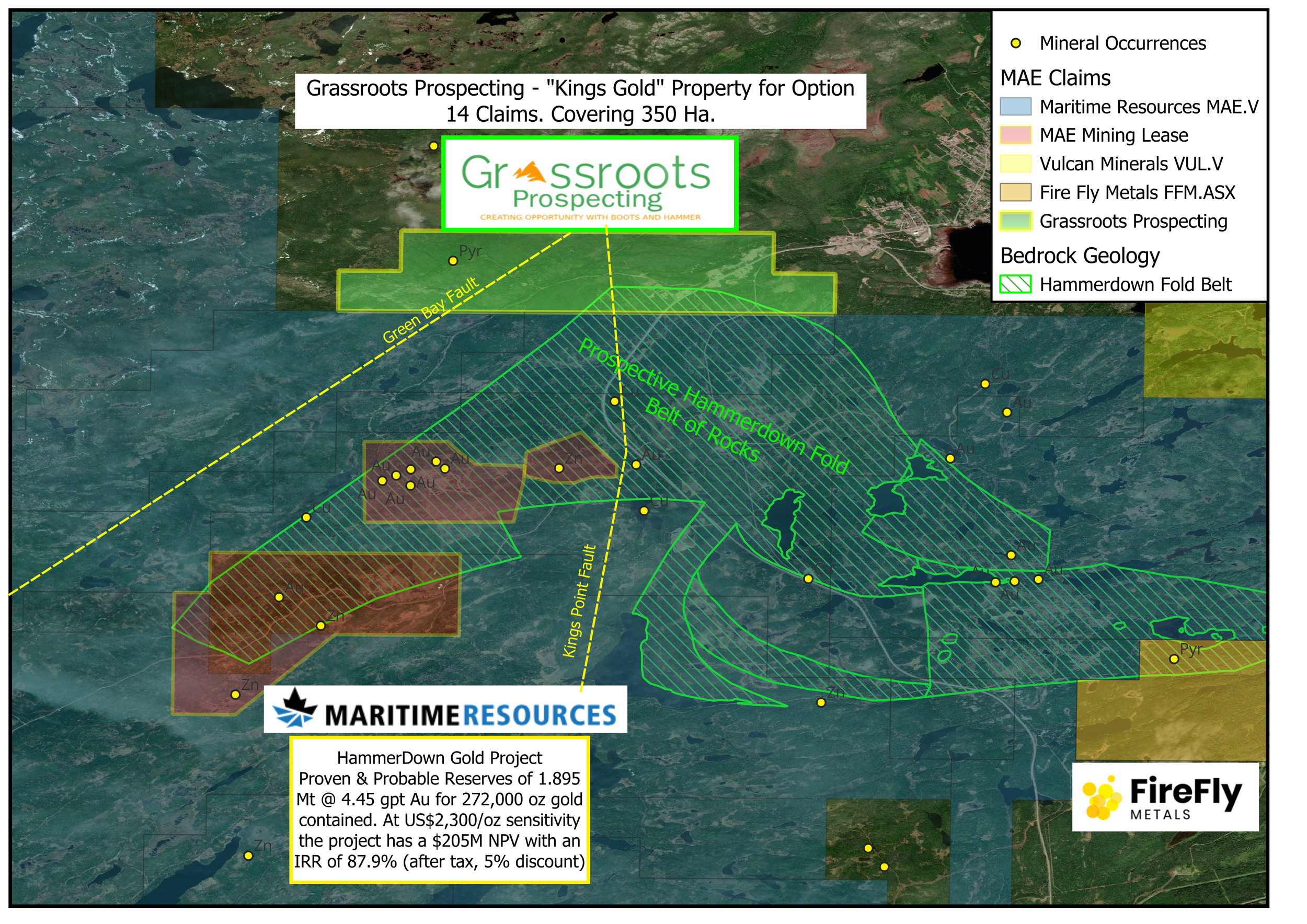
King's Gold
The 100% owned Kings Gold property is located 2.2km south west of the town of Kings Point and adjacent to the Maritimes Resources Corp. Hammer Down Gold Project.
Hammerdown was developed and operated by Richmont Mines between the years 2000 and 2004 with a cut-off grade of 8.5 gpt gold while gold prices averaged US$325/oz. During its operation a total of 291,400 tonnes of ore were mined and milled, at an average grade of 15.83 g/t Au, recovering a total of 143,000 ounces of gold. All of the ore was processed at the Nugget Pond mill with an average gold recovery of 97.1%. Mining concluded in 2004 due to low gold prices with mineralization remaining.
Highlights from the Maritime Resources 2022 Feasibility Study:
Proven & Probable Reserves of 1.895 Mt @ 4.45 gpt Au for 272,000 oz gold contained
1.189 Mt @ 6.76 gpt Au sorted ore mill feed trucked to the Nugget Pond gold plant for 700 tonnes per day of processing throughput with 95% process recovery for gold
Life of mine payable gold production of 247,000 oz, averaging 50,000 ounces annually
$102.8M after tax net present value (“NPV”) (5% discount) with 48.1% internal rate of return (“IRR”), 1.7 year payback at US$1,750/oz base case gold price (three year trailing average)
At US$2,300/oz sensitivity the project has a $205M NPV with an IRR of 87.9% (after tax, 5% discount)
$75.0M estimated initial capital cost with $4.9M in net sustaining capital
US$912/oz gold all-in sustaining cost (“AISC”)
Grassroots 2025 field season plans for this property include prospecting & bedrock mapping.
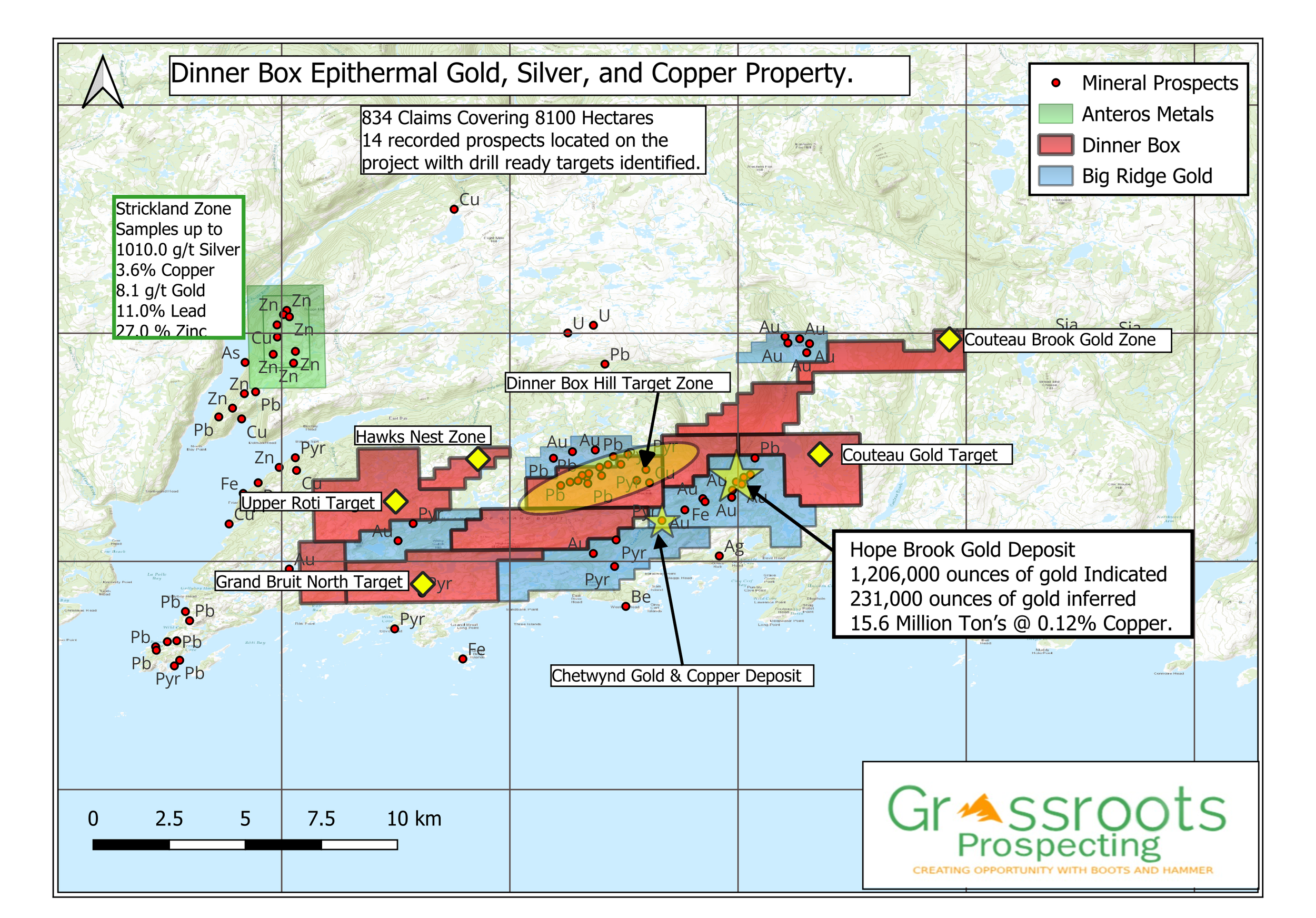
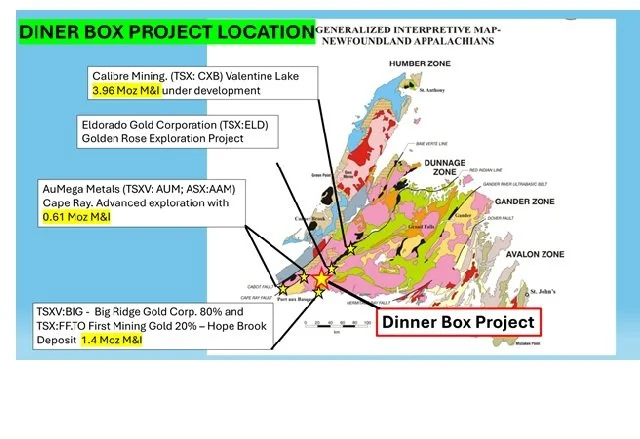
Dinner Box Gold Project
The 100% owned Dinner Box Au property has been acquired by Grassroots through a prospector map staking partnership.
The dinner Box project is located adjacent Big Ridge Gold Hope Brook Gold and Copper Deposit.
BP-Selco made the Hope Brook discovery in 1983 and the mine was put into production in 1987. The Hope Brook Mine was operated from 1987 until 1997 by BP Selco and others and producing 752,163 ounces of gold during that time.
The Mine Zone and 240 Zone remain open along strike and at depth;
Current high-grade gold resource consisting of 1,206,000 ounces of gold in the Indicated category and 231,000 ounces of gold in the inferred category; The deposit also contains 15.6 Million Ton’s @ 0.12% Copper.
Grassroots 2025 exploration plans include compilation of existing historical data and database population. AI Data processing, existing geophysical and spectral imaging data processing, interpretation, and target generation, bedrock structural study and interpretation with a goal to identify the most prospective field follow up areas and drill targets for advancement.